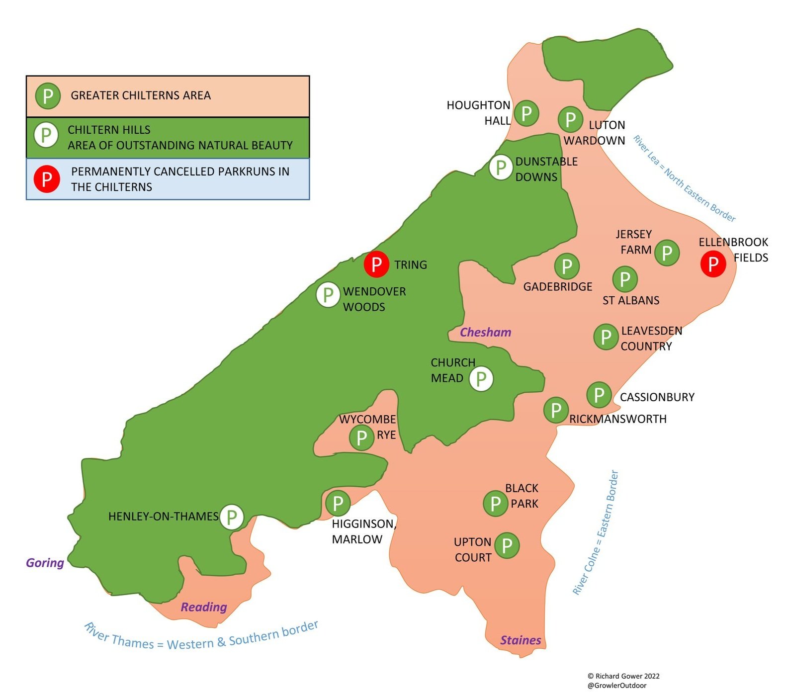
The Chiltern Hills Area of Outstanding Natural Beauty (AONB) is a picturesque landscape located in the southeast of England. It covers an area of approximately 324 square miles and spans across four counties: Oxfordshire, Buckinghamshire, Bedfordshire, and Hertfordshire. The hills are characterized by rolling chalk hills, ancient woodlands, and charming villages with thatched roofs. It is a popular destination for hikers, cyclists, and nature lovers who come to enjoy the stunning vistas and the rich biodiversity of the area. The area is also rich in history and has many sites of archaeological and historical interest, such as Iron Age forts and medieval churches.
The map below shows the AONB plus a larger area that I’ve called the “Greater Chilterns”. This extends to the south and east of the AONB to the banks of the rivers Thames, Colne and Lea. Having lived in or near the Chilterns for much of my life it’s been a regular feature of my walks, runs and cycle trips. This page is an index of the circular and point-to-point walks that I’ve done in the Greater Chilterns Area.
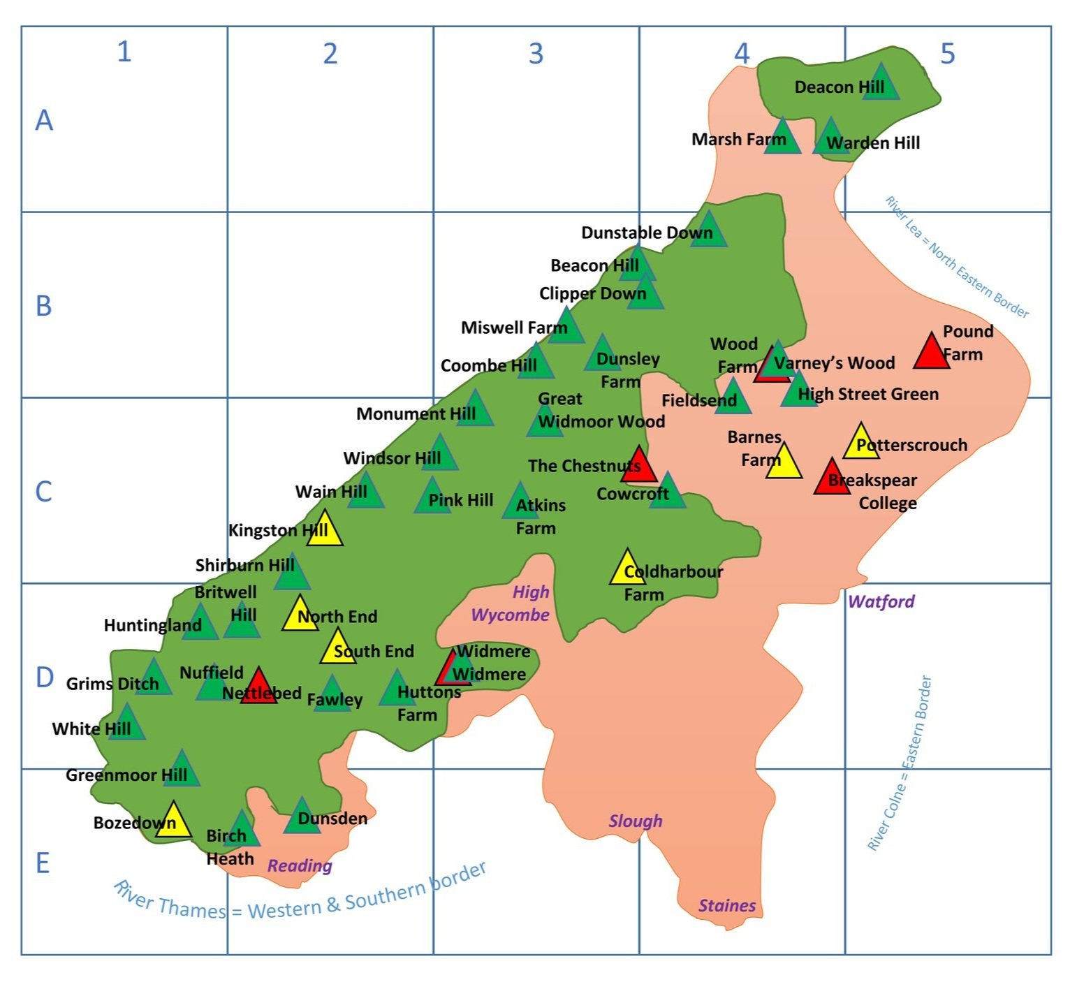
Circular Walks In The Chilterns AONB
Walks shown in alphabetical order of the 2-letter abbreviation on the map above. The letter and number in brackets refers to the grid reference. For more details on each, click on the link on the name of each walk.
AB (D2) Middle Assendon, Bix and Crocker End. Distance = 10.9 km (6.8 miles). +/- 190m elevation change.
AO (C3) Amersham Old and New Towns. Distance = 8.3 km (5.2 miles). +/- 75m elevation change.
AT (B4) Ashridge Boundary Trail. Distance = 26.3 km (16.3 miles). +/- 370m elevation change.
or, split into 4 smaller circular routes:
- AT1: Ivinghoe Beacon and Clipper Down: Distance = 10.3 km (6.4 miles). +/- 185m elevation change.
- AT2: Ashridge Golf Club and Moneybury Hill: Distance = 8.2 km (5.1 miles). +/- 94m elevation change.
- AT3: Northchurch Common and Berkhamsted Common: Distance = 10.2 km (6.4 miles). +/- 125m elevation change.
- AT4: Berkhamsted Common and Frithsden: Distance = 8.9 km (5.5 miles). +/- 106m elevation change.AW (C3) Amersham, Winchmore Hill and Penn. Distance = 12.5 km (7.8 miles). +/- 119m elevation change.
BC (B4) Berkhamsted Castle and Common. Distance = 10.5 km (6.5 miles). +/- 123m elevation change.
BK (D3) Beaconsfield, Knotty Green and Seer Green. Distance = 10.6 km (6.6 miles). +/- 84m elevation change.
BS (D1) Britwell Salome and Lower Warren. Distance: 7.8 km (4.8 miles). +/- 123m elevation change.
BW (D3) Bourne End, Cookham and Wooburn. Distance: 8.2 km (5.1 miles). +/- 83m elevation change.
CA (C3) Coleshill and Amersham. Distance = 11.5 km (7.1 miles). +/- 118m elevation change.
CB (C2) Christmas Common and Bald Hill. Distance: 12.1 km (7.5 miles). +/- 270m elevation change.
CC (C4) Chorleywood, Chess and Chenies. Distance = 8.0 km (5.0 miles). +/- 85m elevation change.
CH (B3) Wendover and Coombe Hill. Distance = 7.3 km (4.5 miles). +/- 139m elevation change.
CT (C4) Chesham & Tylers Hill. Distance = 9.3 km (5.8 miles). +/- 84m elevation change.
CW (D2) Christmas Common, Watlington Hill and Greenfield. Distance = 10.9km km (6.8 miles). +/- 239m Elevation change.
FS (D2) Freith, Skirmett and Moorend Wood. Distance: 8.9 km (5.5 miles). +/- 136m elevation change.
FV (D3) Forty Green and Vicarage Wood. Distance = 8.3 km (5.2 miles). +/- 140m elevation change.
GB (C3) Great Missenden and Ballinger. Distance = 9.8 km (6 miles). +/- 113m elevation change.
GL (C3) Great Missenden and Little Kingshill. Distance = 10.0 km (6.1 miles). +/- 112m elevation change.
GS (E1) Goring & Streatley Station Circular. Distance = 8.9 km (5.5 miles). +/- 155m elevation change.
HL (D2) Henley, Middle Assendon and Lambridge Wood. Distance = 10.9 km (6.8 miles). +/- 185m elevation change.
HM (C3) Hughenden Monument. Distance = 3.4 km (2.1 miles). +/- 89m elevation change.
HR (D2) Hambleden & Rotten Row. Distance = 6 km (3.7 miles). +/- 134m elevation change.
LC (C4) Latimer and Codmore Wood. Distance = 7.7 km (4.8 miles). +/- 120m elevation change.
LF (D2) Lane End, Fingest and Moorend Common. Distance: 8.7 km (5.4 miles). +/- 160m elevation change.
LG (C3) Speen and Lacey Green. Distance = 7.4 km (4.6 miles). +/- 125m elevation change.
LH (C3) Little Missenden and Holmer Green. Distance = 9.8 km (6 miles). +/- 77m elevation change.
LL (C4) Little Chalfont & Latimer. Distance = 8.4 km (5.2 miles). +/- 140m elevation change.
LS (C3) Little Missenden and Shardeloes. Distance = 8.1 km (5.0 miles). +/- 74m elevation change.
MB (D2) Marlow, Hurley, Temple and Bisham. Distance = 8.8 km (5.5 miles). +/- 37m elevation change.
MH (D2) Hambleden and Medmenham. Distance: 9.1 km (5.6 miles). +/- 85m elevation change.
MW (B3) Miswell Farm & Wendover Arm. Distance = 3.4 km (2.1 miles). +/- 20m elevation change.
NH (D2) North-East Hambleden Circular. Distance: 9.7 km (6 miles). +/- 145m elevation change.
NP (D2) Nettlebed, Park Corner and Maidensgrove. Distance: 8.5 km (5.3 miles), +/- 159m elevation change.
NW (C3) Naphill and West Wycombe. Distance = 10.0 km (6.1 miles). +/- 191m elevation change.
PB (C2) Piddington and Bottom Wood. Distance: 7.9 km (4.9 miles). +/- 105m elevation change.
PH (B3) Pavis Wood and Haddington Hills. Distance = 10.2 km (6.3 miles). +/- 157m elevation change.
PW (C3) Penn Wood. Distance: 6.3 km (3.9 miles). +/- 75m elevation change.
RP (D2) Russell's Water, Pishill and Maidensgrove. Distance = 9.2 km (5.7 miles). +/- 166m elevation change
RR (C2) Risborough Railways Ramble. Distance = 10.7 km (6.6 miles). +/- 83m elevation change.
RW (D2) Stokenchurch and The Ridgeway. Distance: 10.6 km (6.6 miles). +/- 231m elevation change.
SB (C3) Saunderton and Bradenham. Distance: 7.8 km (4.8 miles), +/- 170m elevation change.
SF (C4) Sarratt and Flaunden. Distance = 9.8 km (6 miles). +/- 98m elevation change.
SG (D4) Chalfont St Peter, Seer Green and Chalfont St Giles. Distance = 13.1 km (8.1 miles). +/- 121m elevation change.
SK (D2) Skirmett the Frog. Distance = 5.5 km (3.4 miles). +/- 164m elevation change.
SL (C3) Saunderton and Loosley Row. Distance = 9.1 km (5.8 miles). +/- 125m elevation change.
SR (D2) Stokenchurch and Radnage. Distance: 9 km (5.6 miles). +/- 182m elevation change.
Sw1 (D1) Swyncombe and The North. Distance: 8.1 km (5 miles). +/- 176m elevation change.
Sw2 (D1) Swyncombe and Park Corner. Distance: 9.9 km (6.2 miles). +/- 199m elevation change.
Sw3 (D1) Swyncombe and Ewelme. Distance: 10.7 km (6.6 miles). +/- 232m elevation change.
TF (D2) Turville, Fingest and Ibstone. Distance = 11.2 km (6.9 miles). +/- 183m elevation change.
TP (B3) Tring Park and Northfield. Distance = 9.3 km (5.8 miles). +/- 138m elevation change.
WA1 (B3) Wendover Arm Canal Section 1: Wendover to Stablebridge Road. Distance: 10.8 km (6.7 miles). +/- 166m elevation change.
WA2 (B3) Wendover Arm Canal Section 2: Stablebridge Road to Miswell Farm. Distance: 8.9 km (5.5 miles). +/- 157m elevation change.
WA3 (B3) Wendover Arm Canal Section 3: Miswell Farm to Marsworth. Distance: 9.7 km (6 miles). +/-61m elevation change.
WC (C3) Whiteleaf and Cadsden. Distance = 6.4 km (4 miles). +/- 122m elevation change.
WE (D2) Piddington and Wheeler End. Distance: 8.5 km (5.3 miles). +/- 145m elevation change.
WH (C3) Winchmore Hill and Common Wood. Distance = 10.4 km (6.5 miles). +/- 141m elevation change.
WR (D1) Watlington and The Ridgeway. Distance: 7.9 km (4.9 miles). +/- 59m elevation change.
WT (D2) Watlington Hill. Distance = 3.6 km (2.2 miles). +/- 104m elevation change.
WW (C2) Piddington and West Wycombe. Distance: 8 km (5 miles). +/- 243m elevation change.
Circular Walks In The Greater Chilterns Region
Walks shown in alphabetical order of the 2-letter abbreviation on the map above. The letter and number in brackets refers to the grid reference. For more details on each, click on the link on the name of each walk.
AW (E4) Ankerwycke and Wraysbury. Distance = 8.8 km (5.5 miles). +/- 33m elevation change.
BB (B3) Burnham Beeches Perimeter. Distance = 6.4 km (4 miles). +/- 136m elevation change.
BH (D4) Hedgerley and Bulstrode. Distance = 6.9 km (4.3 miles). +/- 53m elevation change.
CW (C5) Cassiobury, Whippendell Woods and Croxley Green. Distance = 10.1 km (6.3 miles). +/- 84m elevation change.
DG (D4) Denham Golf Club and Bakers Wood. Distance = 4.9 km (3.0 miles). +/- 67m elevation change.
DV (E4) Denham Village and Country Park. Distance = 4.4 km (2.7 miles). +/- 20m elevation change.
GC (D4) Gerrards Cross and Chalfont St Peter. Distance = 6.3 km (3.9 miles). +/- 49m elevation change.
GN (D4) Chalfont St Giles and Newlands Park. Distance = 8.6 km (5.3 miles). +/- 75m elevation change.
HB (D4) Heronsgate and Bottom Wood. Distance = 6.5 km (4.0 miles). +/- 82m elevation change.
HC (D3) Hedgerley Circular. Distance = 9.1 km (5.6 miles). +/- 86m elevation change.
MD (D3) Marlow Donkey. Distance = 11.4 km (7 miles). +/- 65m elevation change.
RC (C4) Rickmansworth and Chorleywood. Distance = 9.3km (5.8 miles). +/- 100m elevation change.
RT (C4) Rickmansworth Three Rivers. Distance = 11.4 km (7 miles). +/- 59m elevation change.
SH (E2) Shiplake and Henley-on-Thames. Distance = 8.8 km (5.5 miles). +/- 80m elevation change.
SJ (D3) Seer Green and Jordans. Distance = 7.3 km (4.5 miles). +/- 47m elevation change.
SS (E2) Shiplake, Binfield Heath and Sonning Eye. Distance = 13.1 km (8.1 miles). +/- 105m elevation change.
WG (D3) Wooburn Green & Flackwell Heath. Distance = 6.4 km (4 miles). +/- 136m elevation change.
VW (B4) Varneys Wood & River Gade. Distance = 5 km (3.1 miles). +/- 64m elevation change.
Thames Path & Jubilee River Collection
Walks shown in geographical order from north-west to south-east. For more details on each, click on the link on the name of each walk.
TJ1 (E3) Maidenhead & Bray. Distance = 10.7 km (6.6 miles). +/- 35m elevation change.
TJ2 (E3) Dorney & Eton Wick. Distance = 9.9 km (6.1 miles). +/- 25m elevation change.
TJ2 (E3) Eton Wick and Eton. Distance = 7.9 km (4.9 miles). +/- 22m elevation change.
TJ4 (E3) Eton and Datchet. Distance = 7.4 km (4.6 miles). +/- 22m elevation change.
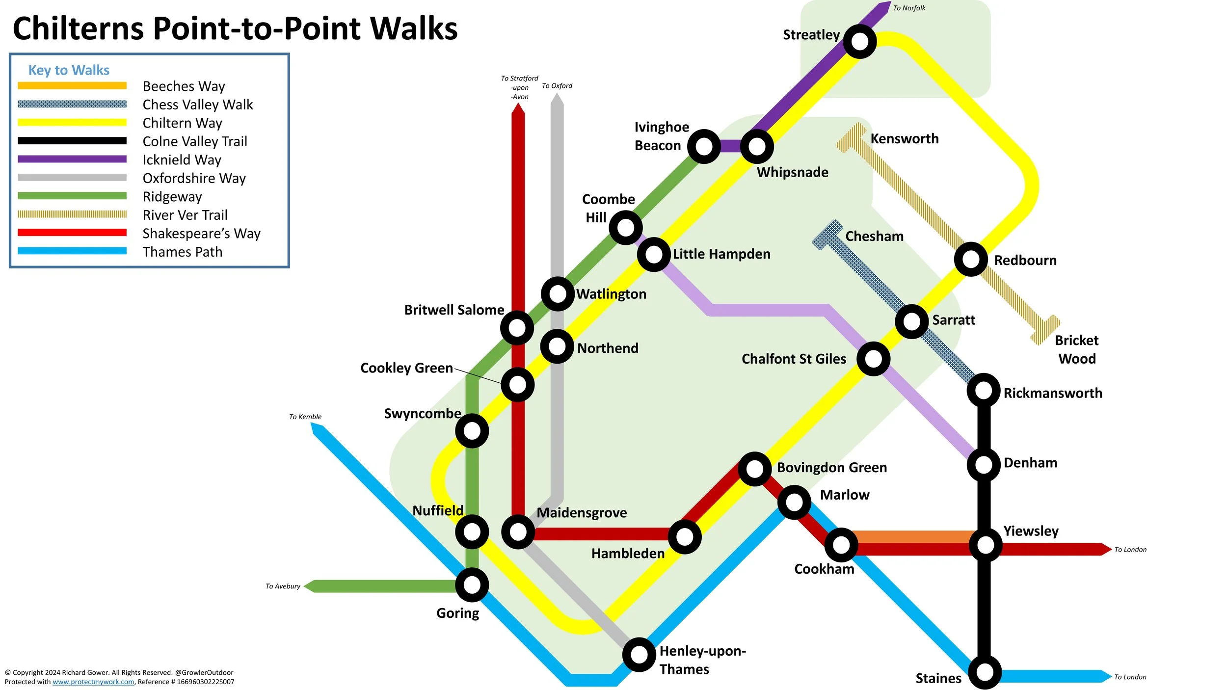
Named & Waymarked Point-to-Point Trails
Beeches Way in 3 sections. Total distance = 26.8 km (16.8 miles). +195m / -195m elevation change.
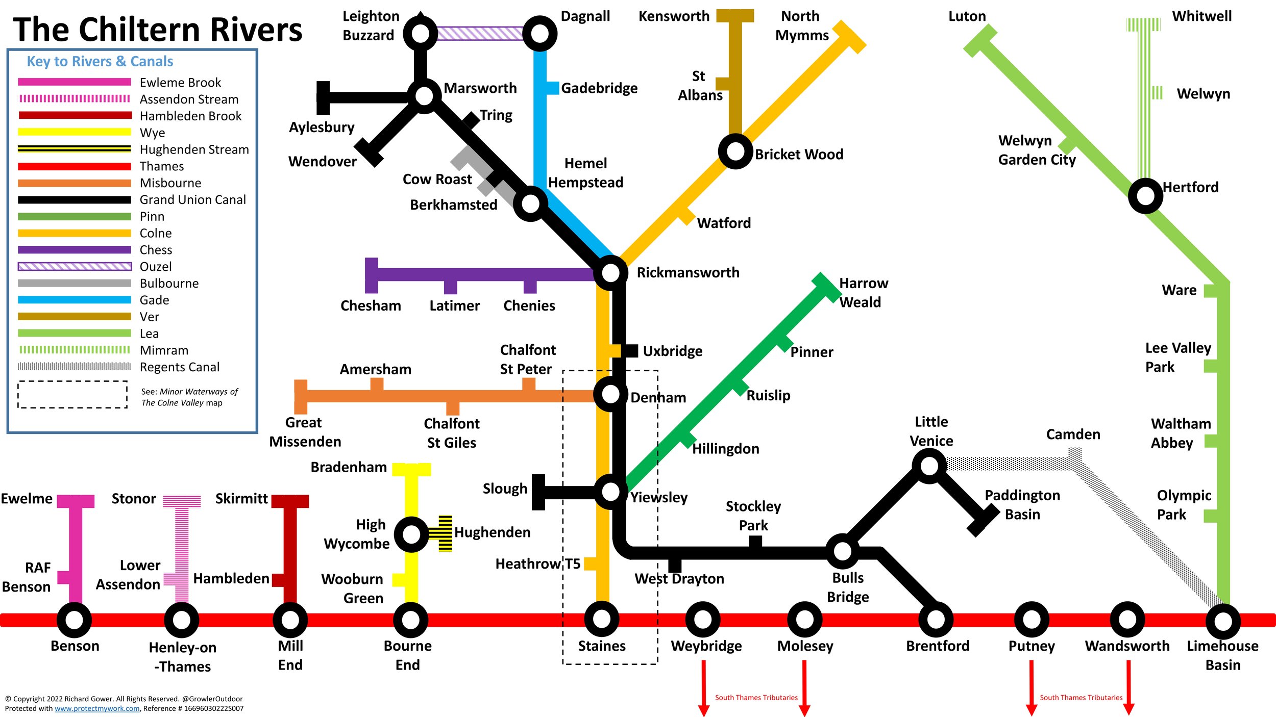
Chess Valley Walk: Distance = 20 km (12.4 miles). +309m / -256m elevation change.
Chiltern Way in 9 sections. Total distance = 215 km (134 miles)
Colne Valley Trail in 4 sections. Distance = Total 33 km (20.6 miles). +121m / -33m elevation change.
Icknield Way Chilterns Section: Part 1: Ivinghoe Beacon to Chalk Hill. Distance = 17 km (10.6 miles). +209m / -293m elevation change.
Icknield Way Chilterns Section Part 2: Chalk Hill to Pirton. Distance = 31 km (19 miles). +435m / -470m elevation change.
Oxfordshire Way Chilterns Section in 4 sections. Total distance = 18.5 km (11.5 miles). + 378 / - 298m elevation change.
Ridgeway: Lewknor to Ivinghoe Beacon In 5 sections. Total distance = Total 44.6 km (27.8 miles). +697m / -618m elevation change.
River Ver Trail. Distance = 28.2 km (17.5 miles). +103m /-226m elevation change.
Other Point to Point Walks
(not shown in tube map above)
Walking The Slough Arm Canal. Distance = 10 km (6.2 miles). +/- 28m elevation change.
High Wycombe To Bourne End Disused Railway. Distance = 9.9 km (6.2 miles). +37m / -86m elevation change.
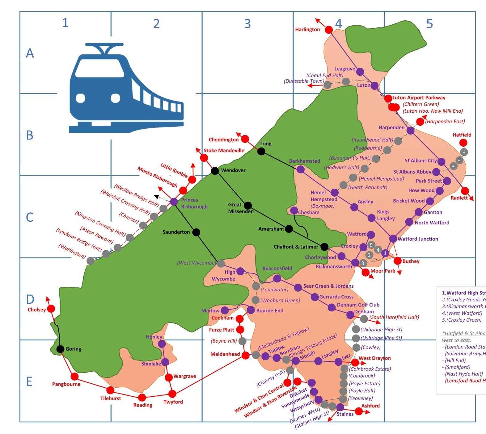
Train out, walk back: The Chinnor and Princes Risborough Railway. Distance = 6.3 km (3.9 miles). +73m / -46m elevation change.
Hughenden Stream: Hughenden Village to High Wycombe. Distance = 4.1 km (2.5 miles). +15m /- 42m elevation change.
More Chiltern Blog Posts