There are currently 85 parkrun events in Scotland of which I have completed 8. The first was Pollok parkrun which started on December 6th 2008 and the newest is Ae Forest which started on July 25th 2026. The name for having completed all parkrun events in Scotland is ALLba
Only one 5k parkrun event has been permanently cancelled in Scotland. Inverness parkrun was held from September 2011 to March 14th 2020 and was replaced by Torvean parkrun
Numbers exclude 2k Junior parkruns and any events that are not open to the general public such as prisons or armed forces facilities.

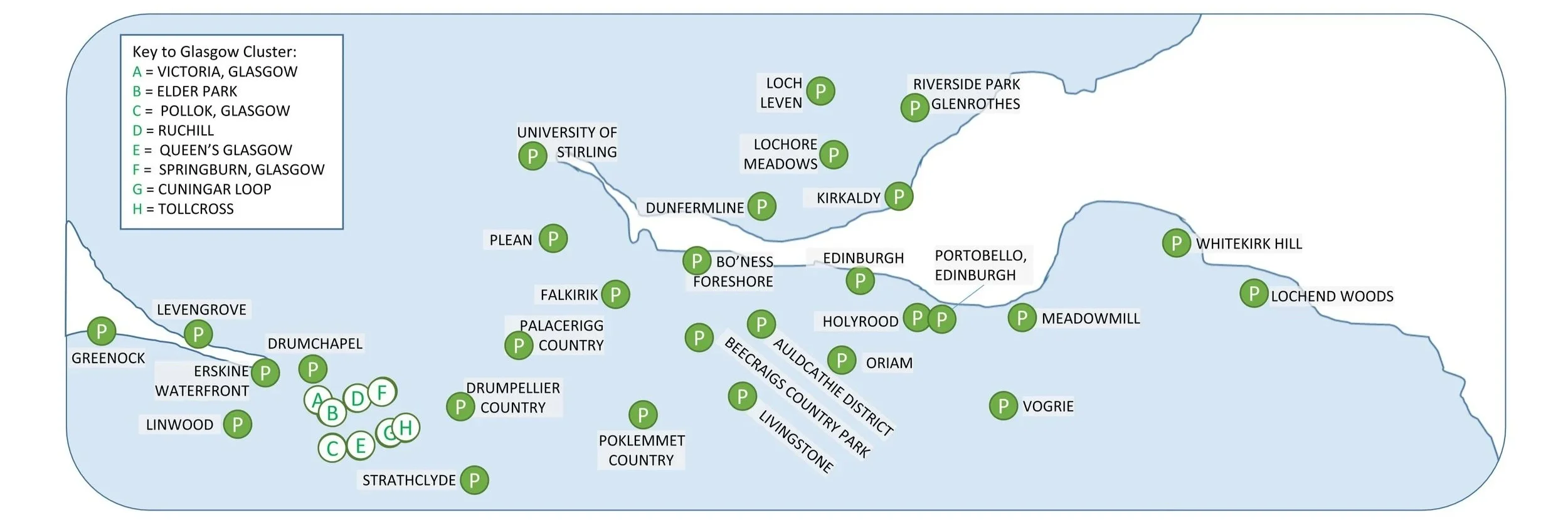
The Central Belt:
Scottish parkruns by County
If you are looking through the list of Scottish parkruns below, you’ll notice that I have included both the Historic County and the present-day Council Area for each event. The Historic Counties are the traditional geographical divisions of Scotland. These boundaries were established centuries ago, some tracing their origins back to the Middle Ages, and they were formally used for local administration from the late 19th century right up until 1975. Today, these boundaries remain static, offering a fascinating glimpse into the map history and traditional cartography of the landscape we are running through.
The present-day Council Areas are Scotland’s modern administrative units. The current system of 32 single‑tier councils came into effect on 1 April 1996, replacing the two‑tier structure of regions and districts that had existed since 1975. These councils handle local services such as waste collection, education, and planning.
Lanarkshire is the Historic County with the most 5k parkrun events with 9.
Highland is the Council Area with the most 5k parkrun events with 9.

All of the Scottish parkrun events …
Below are each of the Scottish 5k parkrun events in alphabetical order. A few things to note:
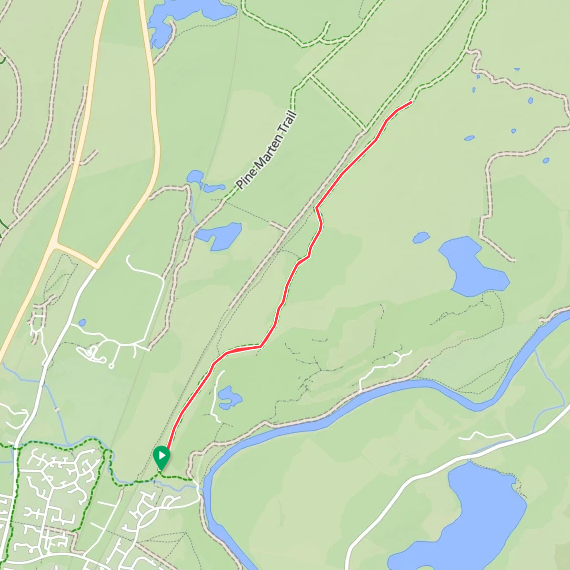
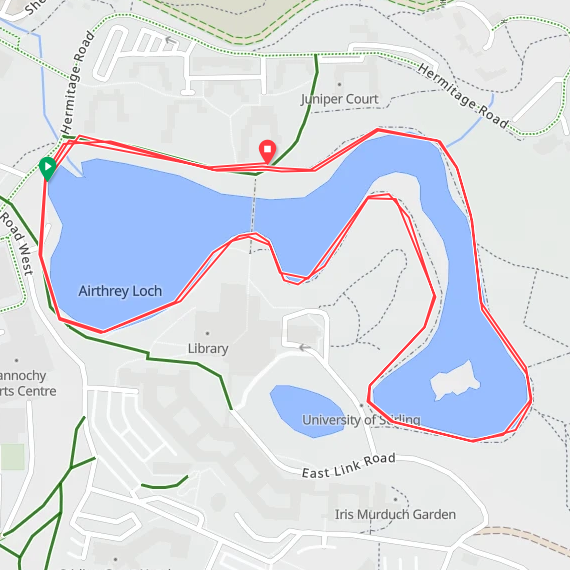
The interactive maps below take you to the approximate location for the course, typically the centre of the park. See the course instructions in the parkrun page for each event for specific directions to the start.
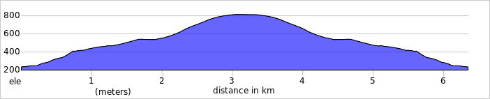
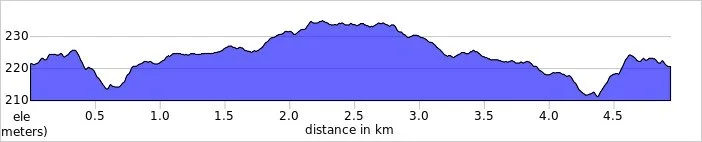
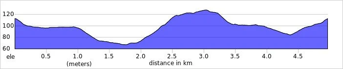
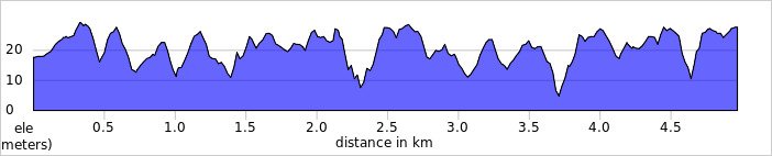
Course maps and elevation profiles show the route at the time that I ran it and may have changed since then. See the Course page in the event’s page on parkrun.org.uk for the current course outline. Note that course outlines are from Garmin data during a specific run and may vary from the officially measured distance.
Please contact me if you spot an event that doesn’t have a course map and elevation profile and you would like to donate one from your own run. I’m also interested in maps and elevation profiles for courses that have changed or where there’s a regular alternative route (e.g. Horsham). I’ll need a GPX file from your run plus the date. I’ll include a credit for you and will donate £1 to parkrun.
Aberdeen
I have not yet completed this event
Historic County: Aberdeenshire
Council Area: Aberdeen City
Inaugural: October 8th 2011
Links: Event Home Page, Course Page
Ae Forest
I have not yet completed this event
Historic County: Dumfriesshire
Council Area: Dumfries and Galloway
Inaugural: July 25th 2026
Links: Event Home Page, Course Page
Agnew
I have not yet completed this event
Historic County: Wigtownshire
Council Area: Dumfries and Galloway
Inaugural: December 14th 2019
Links: Event Home Page, Course Page
Alness
I have not yet completed this event
Historic County: Ross-shire / Ross and Cromarty
Council Area: Highland
Inaugural: August 26th 2017
Links: Event Home Page, Course Page
Anagach Woods
I have not yet completed this event
Historic County: Morayshire
Council Area: Highland
Inaugural: August 23rd 2025
Links: Event Home Page, Course Page
Auldcathie District
I have not yet completed this event
Historic County: West Lothian
Council Area: West Lothian
Inaugural: January 7th 2023
Links: Event Home Page, Course Page
Aviemore
I completed this event on: June 14th 2025 with a finish time of: 25:43
Other routes touched (walk): Speyside Way
Other routes touched (cycle): NCN 7
Historic County: Inverness-shire
Council Area: Highland
Inaugural: May 6th 2017
Links: Event Home Page, Course Page
Ayr
I have not yet completed this event
Historic County: Ayrshire
Council Area: South Ayrshire
Inaugural: September 20th 2014
Links: Event Home Page, Course Page
Beecraigs Country Park
I have not yet completed this event
Historic County: West Lothian
Council Area: West Lothian
Inaugural: December 27th 2025
Links: Event Home Page, Course Page
Belladrum
I have not yet completed this event
Historic County: Inverness-shire
Council Area: Highland
Inaugural: January 24th 2026
Links: Event Home Page, Course Page
Bo’ness Foreshore
I have not yet completed this event
Historic County: West Lothian
Council Area: Falkirk
Inaugural: October 4th 2025
Links: Event Home Page, Course Page
Bressay
I have not yet completed this event
Historic County: Shetland
Council Area: Shetland Islands
Inaugural: January 20th 2018
Links: Event Home Page, Course Page
Broughty Ferry Esplanade
I have not yet completed this event
Historic County: Angus
Council Area: Dundee City
Inaugural: June 27th 2026
Links: Event Home Page, Course Page
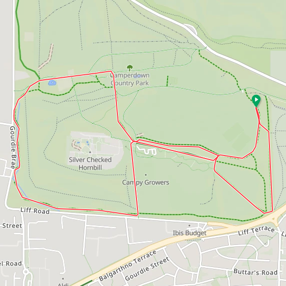
Camperdown
I completed this event on: September 28th 2024 with a finish time of: 27:05
Other routes touched: None
Historic County: Angus
Council Area: Dundee City
Inaugural: May 19th 2012
Links: Event Home Page, Course Page
Carlingwark Loch
I have not yet completed this event
Historic County: Kirkcudbrightshire
Council Area: Dumfries and Galloway
Inaugural: October 21st 2023
Links: Event Home Page, Course Page
Castle Woods
I have not yet completed this event
Historic County: Aberdeenshire
Council Area: Aberdeenshire
Inaugural: May 17th 2025
Links: Event Home Page, Course Page
Crathes Castle
I have not yet completed this event
Historic County: Aberdeenshire
Council Area: Aberdeenshire
Inaugural: February 9th 2019
Links: Event Home Page, Course Page
Crichton
I have not yet completed this event
Historic County: Dumfriesshire
Council Area: Dumfries and Galloway
Inaugural: January 6th 2018
Links: Event Home Page, Course Page
Crinan Canal
I have not yet completed this event
Historic County: Argyllshire
Council Area: Argyll and Bute
Inaugural: August 31st 2024
Links: Event Home Page, Course Page
Cuningar Loop
I have not yet completed this event
Historic County: Lanarkshire
Council Area: South Lanarkshire
Inaugural: March 8th 2025
Links: Event Home Page, Course Page
Dean Castle Country Park
I have not yet completed this event
Historic County: Ayrshire
Council Area: East Ayrshire
Inaugural: August 31st 2019
Links: Event Home Page, Course Page
Drumchapel
I have not yet completed this event
Historic County: Dunbartonshire
Council Area: Glasgow City
Inaugural: June 4th 2016
Links: Event Home Page, Course Page
Drumlarig Castle
I have not yet completed this event
Historic County: Dumfriesshire
Council Area: Dumfries and Galloway
Inaugural: May 9th 2026
Links: Event Home Page, Course Page
Drumpellier Country
I have not yet completed this event
Historic County: Lanarkshire
Council Area: North Lanarkshire
Inaugural: July 27th 2019
Links: Event Home Page, Course Page
Dunfermline
I have not yet completed this event
Historic County: Fife
Council Area: Fife
Inaugural: July 4th 2015
Links: Event Home Page, Course Page
Edinburgh
I have not yet completed this event
Historic County: Midlothian
Council Area: City of Edinburgh
Inaugural: October 17th 2009
Links: Event Home Page, Course Page
Eglinton
I have not yet completed this event
Historic County: Ayrshire
Council Area: North Ayrshire
Inaugural: March 16th 2013
Links: Event Home Page, Course Page
Elder Park
I have not yet completed this event
Historic County: Lanarkshire
Council Area: Glasgow City
Inaugural: June 11th 2022
Links: Event Home Page, Course Page
Elgin
I have not yet completed this event
Historic County: Morayshire
Council Area: Moray
Inaugural: March 5th 2016
Links: Event Home Page, Course Page
Ellon
I have not yet completed this event
Historic County: Aberdeenshire
Council Area: Aberdeenshire
Inaugural: October 17th 2015
Links: Event Home Page, Course Page
Erskine Waterfront
I have not yet completed this event
Historic County: Renfrewshire
Council Area: Renfrewshire
Inaugural: November 19th 2022
Links: Event Home Page, Course Page
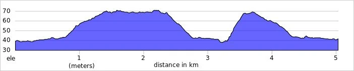
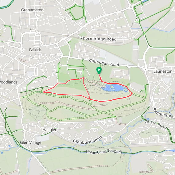
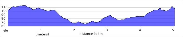
Falkirk
I completed this event on: August 10th 2024 with a finish time of: 28:08
Other routes touched (walk): John Muir Way
Other routes touched (cycle): HArRTT
Historic County: Stirlingshire
Council Area: Falkirk
Inaugural: July 16th 2011
Links: Event Home Page, Course Page
Faskally Forest
I have not yet completed this event
Historic County: Perthshire
Council Area: Perth and Kinross
Inaugural: March 7th 2020
Links: Event Home Page, Course Page
FeldyRoo Fitness Trail
I have not yet completed this event
Historic County: Perthshire
Council Area: Perth and Kinross
Inaugural: April 12th 2025
Links: Event Home Page, Course Page
Forfar Loch
I have not yet completed this event
Historic County: Angus
Council Area: Angus
Inaugural: February 12th 2022
Links: Event Home Page, Course Page
Fort William
I completed this event on: August 17th 2024 with a finish time of: 28:02
Other routes touched: None
Historic County: Inverness-shire
Council Area: Highland
Inaugural: April 7th 2018
Links: Event Home Page, Course Page

Ganavan Sands
I have not yet completed this event
Historic County: Argyllshire
Council Area: Argyll and Bute
Inaugural: August 20th 2016
Links: Event Home Page, Course Page
Girvan Prom
I have not yet completed this event
Historic County: Ayrshire
Council Area: South Ayrshire
Inaugural: July 28th 2018
Links: Event Home Page, Course Page
Greenock
I have not yet completed this event
Historic County: Renfrewshire
Council Area: Inverclyde
Inaugural: May 17th 2014
Links: Event Home Page, Course Page
Hay Lodge
I have not yet completed this event
Historic County: Peeblesshire
Council Area: Scottish Borders
Inaugural: November 3rd 2018
Links: Event Home Page, Course Page
Hazlehead
I have not yet completed this event
Historic County: Aberdeenshire
Council Area: Aberdeen City
Inaugural: August 16th 2014
Links: Event Home Page, Course Page
Holyrood
I have not yet completed this event
Historic County: Midlothian
Council Area: City of Edinburgh
Inaugural: July 16th 2022
Links: Event Home Page, Course Page
Inverness
***Inverness parkrun is now permanently cancelled ***
I did not complete this event before it was closed
County: Inverness-shire / Highland
Inaugural: September 3rd 2011. Final event: #432 on March 14th 2020
Reason for cancellation: Original venue became unavailable
Replaced by: Torvean
Links: Event Home Page
Kirkcaldy
I have not yet completed this event
Historic County: Fife
Council Area: Fife
Inaugural: February 14th 2015
Links: Event Home Page, Course Page
Kirkwall
I have not yet completed this event
Historic County: Orkney
Council Area: Orkney Islands
Inaugural: April 21st 2018
Links: Event Home Page, Course Page
Lady Mary’s Walk
I have not yet completed this event
Historic County: Perthshire
Council Area: Perth and Kinross
Inaugural: April 18th 2026
Links: Event Home Page, Course Page
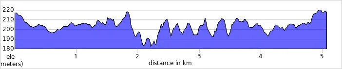
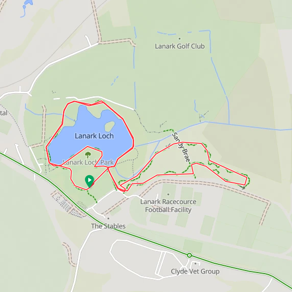
Lanark Moor
I completed this event on: September 25th 2025 with a finish time of: 27:27
Other routes touched: None
Historic County: Lanarkshire
Council Area: South Lanarkshire
Inaugural: August 11th 2018
Links: Event Home Page, Course Page
Largs Prom
I have not yet completed this event
Historic County: Ayrshire
Council Area: North Ayrshire
Inaugural: May 28th 2022
Links: Event Home Page, Course Page
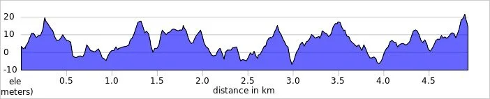
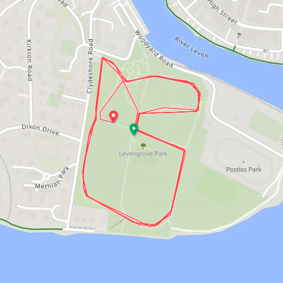
Levengrove
I completed this event on: September 9th 2023 with a finish time of: 26:09
Other routes touched (walk): The Shore Circular Path
Historic County: Dunbartonshire
Council Area: West Dunbartonshire
Inaugural: December 7th 2019
Links: Event Home Page, Course Page
Lews Castle
I have not yet completed this event
Historic County: Ross-shire
Council Area: Outer Hebrides
Inaugural: January 11th 2020
Links: Event Home Page, Course Page
Linwood
I have not yet completed this event
Historic County: Renfrewshire
Council Area: Renfrewshire
Inaugural: July 9th 2016
Links: Event Home Page, Course Page
Livingston
I have not yet completed this event
Historic County: West Lothian
Council Area: West Lothian
Inaugural: January 9th 2016
Links: Event Home Page, Course Page
Loch Leven
I have not yet completed this event
Historic County: Kinross-shire
Council Area: Perth and Kinross
Inaugural: August 11th 2018
Links: Event Home Page, Course Page
Lochend Woods
I have not yet completed this event
Historic County: East Lothian
Council Area: East Lothian
Inaugural: March 23rd 2019
Links: Event Home Page, Course Page
Lochore Meadows
I have not yet completed this event
Historic County: Fife
Council Area: Fife
Inaugural: May 19th 2018
Links: Event Home Page, Course Page
Meadowmill
I have not yet completed this event
Historic County: East Lothian
Council Area: East Lothian
Inaugural: February 9th 2019
Links: Event Home Page, Course Page
Montrose
I have not yet completed this event
Historic County: Angus
Council Area: Angus
Inaugural: July 8th 2017
Links: Event Home Page, Course Page
Mount Stuart
I have not yet completed this event
Historic County: Buteshire
Council Area: Argyll and Bute
Inaugural: September 7th 2019
Links: Event Home Page, Course Page
Nairn Links
I have not yet completed this event
Historic County: Nairnshire
Council Area: Highland
Inaugural: March 29th 2025
Links: Event Home Page, Course Page
Oriam
I have not yet completed this event
Historic County: Midlothian
Council Area: City of Edinburgh
Inaugural: November 2nd 2019
Links: Event Home Page, Course Page
Palacerigg Country
I have not yet completed this event
Historic County: Dunbartonshire
Council Area: North Lanarkshire
Inaugural: August 27th 2022
Links: Event Home Page, Course Page
Perth
I have not yet completed this event
Historic County: Perthshire
Council Area: Perth and Kinross
Inaugural: November 30th 2013
Links: Event Home Page, Course Page
Plean
I have not yet completed this event
Historic County: Stirlingshire
Council Area: Stirling
Inaugural: November 18th 2017
Links: Event Home Page, Course Page
Polkemmet Country
I have not yet completed this event
Historic County: West Lothian
Council Area: West Lothian
Inaugural: May 25th 2019
Links: Event Home Page, Course Page
Pollok, Glasgow
I have not yet completed this event
Historic County: Lanarkshire
Council Area: Glasgow City
Inaugural: December 6th 2008
Links: Event Home Page, Course Page
Portobello, Edinburgh
I have not yet completed this event
Historic County: Midlothian
Council Area: City of Edinburgh
Inaugural: April 18th 2015
Links: Event Home Page, Course Page
Queen’s, Glasgow
I have not yet completed this event
Historic County: Lanarkshire
Council Area: Glasgow City
Inaugural: February 25th 2012
Links: Event Home Page, Course Page
Riverside Park, Glenrothes
I have not yet completed this event
Historic County: Fife
Council Area: Fife
Inaugural: June 14th 2024
Links: Event Home Page, Course Page
Ruchill
I have not yet completed this event
Historic County: Lanarkshire
Council Area: Glasgow City
Inaugural: April 15th 2017
Links: Event Home Page, Course Page
Skinadin
I have not yet completed this event
Historic County: Inverness-shire
Council Area: Highland
Inaugural: August 10th 2024
Links: Event Home Page, Course Page
Springburn
I have not yet completed this event
Historic County: Lanarkshire
Council Area: Glasgow City
Inaugural: May 10th 2014
Links: Event Home Page, Course Page
St Andrews
I have not yet completed this event
Historic County: Fife
Council Area: Fife
Inaugural: April 21st 2012
Links: Event Home Page, Course Page
Stonehaven
I have not yet completed this event
Historic County: Kincardineshire
Council Area: Aberdeenshire
Inaugural: September 10th 2016
Links: Event Home Page, Course Page
Strathclyde
I have not yet completed this event
Historic County: Lanarkshire
Council Area: North Lanarkshire
Inaugural: April 10th 2010
Links: Event Home Page, Course Page
Thurso
I have not yet completed this event
Historic County: Caithness
Council Area: Highland
Inaugural: April 14th 2018
Links: Event Home Page, Course Page
Tollcross
I have not yet completed this event
Historic County: Lanarkshire
Council Area: Glasgow City
Inaugural: May 18th 2013
Links: Event Home Page, Course Page
Torvean
I have not yet completed this event
Historic County: Inverness-shire
Council Area: Highland
Inaugural: September 4th 2021
Links: Event Home Page, Course Page
Troon
I have not yet completed this event
Historic County: Ayrshire
Council Area: South Ayrshire
Inaugural: December 2nd 2017
Links: Event Home Page, Course Page
University of Stirling
I completed this event on: September 24th 2022 with a finish time of: 24:20
Other routes touched (walk): Henry Milne Walk
Historic County: Stirlingshire
Council Area: Stirling
Inaugural: October 12th 2019
Links: Event Home Page, Course Page
Ury Riverside
I have not yet completed this event
Historic County: Aberdeenshire
Council Area: Aberdeenshire
Inaugural: November 2nd 2019
Links: Event Home Page, Course Page
Victoria
I completed this event on: June 6th 2026 with a finish time of: 28:40
Other routes touched: None
Historic County: Lanarkshire
Council Area: Glasgow City
Inaugural: October 12th 2013
Links: Event Home Page, Course Page


Vogrie
I have not yet completed this event
Historic County: Midlothian
Council Area: Midlothian
Inaugural: March 11th 2017
Links: Event Home Page, Course Page
Wallaceneuk
I have not yet completed this event
Historic County: Roxburghshire
Council Area: Scottish Borders
Inaugural: January 18th 2020
Links: Event Home Page, Course Page
West Links
I have not yet completed this event
Historic County: Angus
Council Area: Angus
Inaugural: January 15th 2022
Links: Event Home Page, Course Page
Whitekirk Hill
I have not yet completed this event
Historic County: East Lothian
Council Area: East Lothian
Inaugural: September 16th 2023
Links: Event Home Page, Course Page
Wilton Lodge Park
I have not yet completed this event
Historic County: Roxburghshire
Council Area: Scottish Borders
Inaugural: April 11th 2026
Links: Event Home Page, Course Page
More parkrun posts
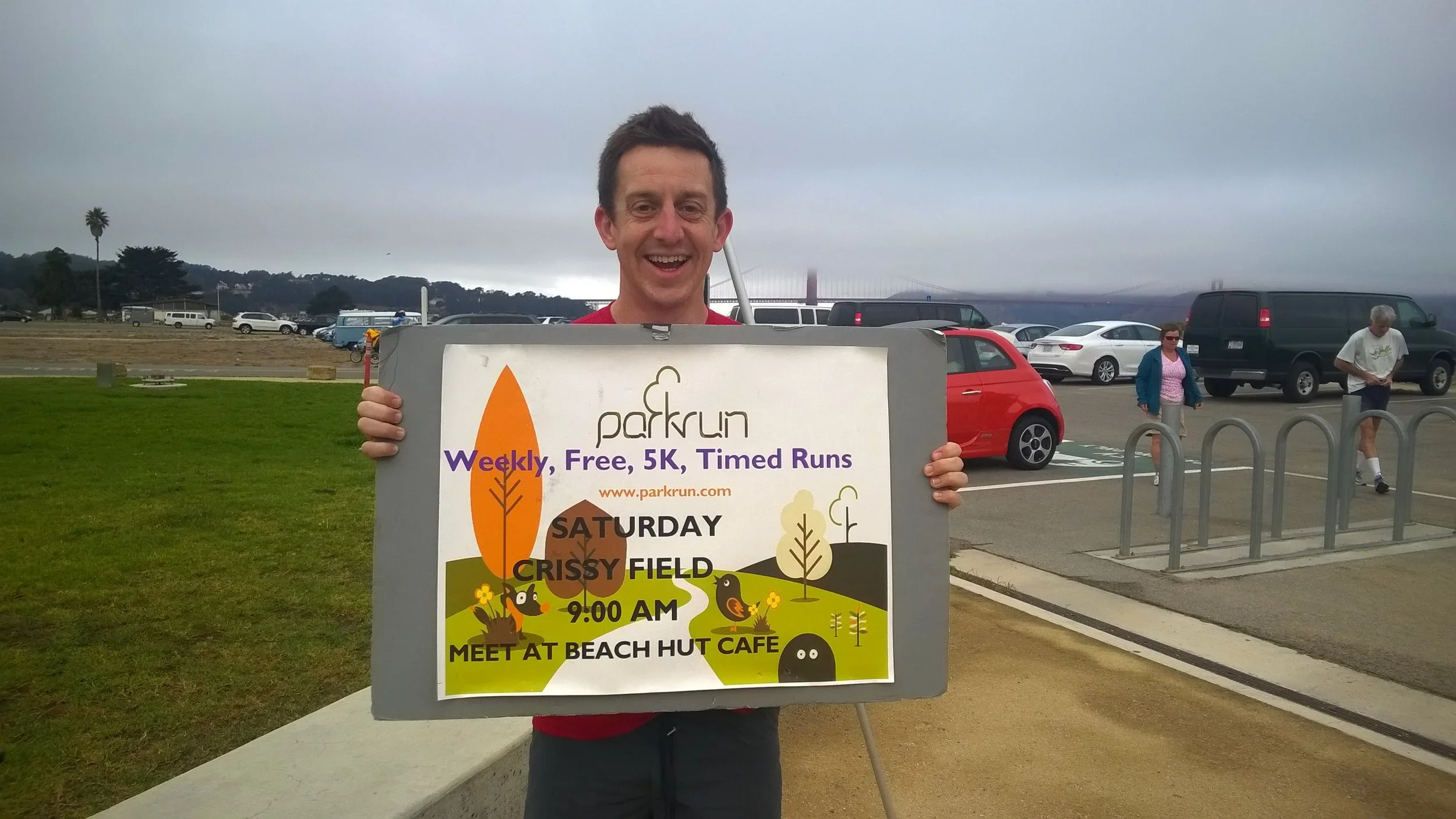
parkruns are free, weekly, community 5k events all around the world. I started in December 2012 and have been obsessive about it ever since. See my parkrun Collection page for details.
Featured and popular parkrun posts: