Walking The River Wandle Trail
Morden Hall Park
Start: East Croydon Station, Croydon CR0 1LF
Finish: Thames Path at Wandsworth, SW18 1EJ
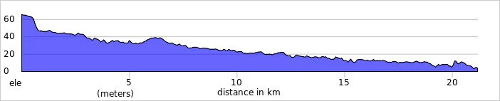
Distance: 21.2 km (13.2 miles)
Elevation change: +55m / -117m. Net -62m
GPX File: get via Buy Me a Coffee
Other routes touched (walk): Vanguard Way, Wandle Oaks Link, Capital Ring, Thames Path
Other routes touched (cycle): NCN 20
Map: OS Explorer Map (161) London South, Westminster, Greenwich, Croydon, Esher & Twickenham
Guidebooks:
- London's Lost Rivers: A Walker's Guide by Tom Bolton
- London's Lost Rivers by Paul Talling
- London's Hidden Rivers: A walker's guide to the subterranean waterways of London by David Fathers
Links: River Wandle, Croydon, Carshalton, Morden Hall Park National Trust, Wandsworth
Just like last week's Lea River trip, this one started in a grim New Town and ended at the Thames in London. There may be some pleasant parts of Croydon, but they are not immediately obvious on this initial stretch of the Wandle.
I was following the river along the course described in Tom Bolton's London's Lost Rivers. Unlike the other subterranean waterways described in the book, the Wandle is mostly still visible today, with only a few sections having been covered up or converted to sewers. Once you leave the concrete of Croydon, it's a very pleasant walk, run, or cycle through some surprisingly green and hidden parts of the capital.
The route starts at the 120-year-old Swan and Sugarloaf at the south end of Croydon High Street. Once a grand historic pub and hotel built in the 1890s, it's now a Tesco Express in a rather dingy part of town, though the beautiful Victorian exterior remains intact. The river has been covered up in this area, so the best plan is to head north quickly. If you are not bothered about visiting the exact historical source, the Wandle surface car park, slightly further up, is an alternative place to start.
The Wandle finally becomes visible about half a mile in at the south-east corner of Wandle Park. Interestingly, the river here was buried in a concrete culvert back in the 1960s but was successfully dug back up and restored to the surface in 2012. The truly scenic part of the trip only really starts at Waddon Ponds—which is actually fed by springs that form one of the river's official sources—and this is where the signs for the Wandle Trail officially begin.
The river meanders for roughly 11 miles through a mix of parks and old industrial areas before reaching the Thames at Wandsworth. Because it drops rapidly in elevation, it used to be one of the hardest-working rivers in the world, powering over 90 mills for everything from copper and leather to lavender and snuff.
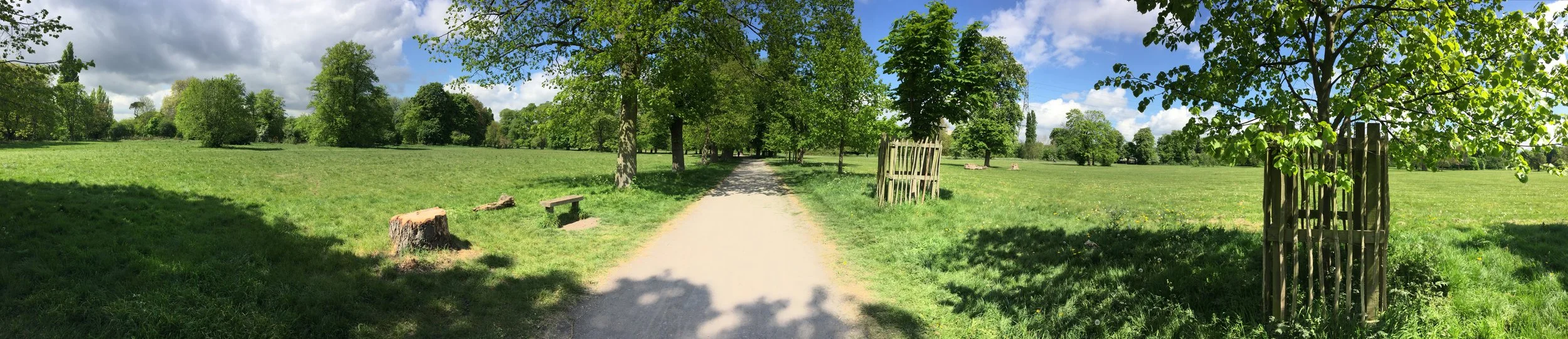
Along the way, there are some brilliant places to stop for a rest. Beddington Park is a highlight; it was originally a Tudor deer park where Henry VIII and Queen Elizabeth I used to hunt. A bit further along is Morden Hall Park, a beautiful National Trust property where you can still see the old snuff mills sitting right over the water.
The confluence with the Thames is just north of Wandsworth centre (the town actually takes its name from the river: the "Wandle's worth" or enclosure). I have crossed the bridge here several times on the Thames Path, completely not realising what it was. From here, I picked up a TfL Santander Cycle just around the corner at Smuggler's Way and took a 6-mile route via the Thames Path to Victoria Station. Regular trains go from here back to West Croydon.


More London Posts
If you enjoyed reading this post, there is plenty more to explore across the capital. I have put together a dedicated London Outdoors page where I keep track of all my other adventures around the city. It is a handy index where I group my posts by the different types of places I have visited: including historic boundary lines, canal towpaths, and some surprising urban high points.
The collection covers a bit of everything: from long-distance cycling routes to tracing the underground network on foot, and ticking off another Saturday morning parkrun. If you are looking for some inspiration for your own weekend outings, head back over to the London Outdoors page to see what else I have been up to.